What is VLBI?
Geodetic Very Long Baseline Interferometry (VLBI) is a microwave-based space geodetic technique that measures the difference in arrival times of signals from a radio source by cross correlation. Most commonly the observed radio sources are extragalactic objects, such as quasars, but beacons from satellites have been used as well. By observing extragalactic objects VLBI is able to connect the surface of the Earth where the telescopes are to the stable celestial background. These observations make it possible to derive an absolute orientation of the Earth, which is one of the advantages of VLBI over other space geodetic techniques.
The short video by NASA Space Geodesy Project (SGP) linked to the right gives a brief and vivid introduction to how VLBI works and what it aims for. Check it out!
Very Long Baseline Interferometry is a major space-geodetic technique. VLBI observations help us to measure, describe and understand where we are and how we move — on our planet as well as relatively to the cosmic background. The long time series of VLBI observations starting in the late 19790s reveal subtle interactions within the Earth system, enable to quantify troposphere parameters for climate studies and allow to assess geodynamic effects, such as plate tectonics or post-glacial rebound. Hence, VLBI is indispensable for numerous scientific, societal and economic tasks and applications.
Why do we need VLBI?
VLBI is indispensable for realizing the most precise and stable reference frames, which serve as a fundamental basis for numerous scientific, societal and economic tasks and applications. VLBI plays a unique role in the practical realization and maintenance of the International Celestial Reference Frame (ICRF) and contributes significantly to the International Terrestrial Reference Frame (ITRF), in particular to its scale determination. A highly stable ITRF with station velocities accurate at the 0.1 mm/year level is a prerequisite to reliably observe mean sea level rise at the order of 3 mm/year and global change phenomena.
The importance of Global Geodetic Reference Frames (GGRF) for any kind of positioning and navigation was recognized at highest levels when in February 2015 the United Nations General Assembly adopted the resolution “A Global Geodetic Reference Frame for Sustainable Development" – the first resolution recognizing the importance of a globally-coordinated approach to geodesy. And VLBI certainly plays an important and unique role there.
VLBI is the only technique that provides the full set of Earth orientation parameters, which are indispensable for positioning and navigation on Earth and in space and give valuable information about interactions within the Earth system. In particular, direct measurements of nutation parameters and of the Earth rotation angle (UT1 – UTC) are uniquely provided by VLBI. Furthermore, several other geodynamic, atmospheric, and astronomical parameters can be derived from the long history of VLBI measurements starting in the late 1970s.
Who does VLBI?
In 1999, the International Association of Geodesy (IAG) accepted the International VLBI Service for Astrometry and Geodesy (IVS) as an official IAG Service, and since then, the coordination of world-wide VLBI observation and analysis has improved significantly, leading to valuable results for the whole scientific community.
The contribution of TU Wien together with the BEV to VLBI and the IVS is carried out by the Vienna VLBI Center.
Where do we go from here?
The geodetic VLBI techniques relies on expensive telescopes which have to be maintained and repaired. Therefore, building new telescopes across the Earth is no easy task. Nevertheless, the VLBI community came together to address this need and came up with the next generation of VLBI which is called VLBI Global Observing System (VGOS). These telescopes are small (12 to 13 m) and very fast slewing (12 deg/s) which make them the optimal instrument for geodetic VLBI. Observations with these antennas has already started with new telescopes being built and added to the network. Significantly improved geodetic products can be expected once the full network is online.
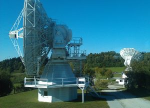
VGOS twin telescope at Wettzell, Germany.